Aviation Data
Design Notes
[ airports | runways | navaids | fixes | routes | legs || csv | sgb | sqlite ]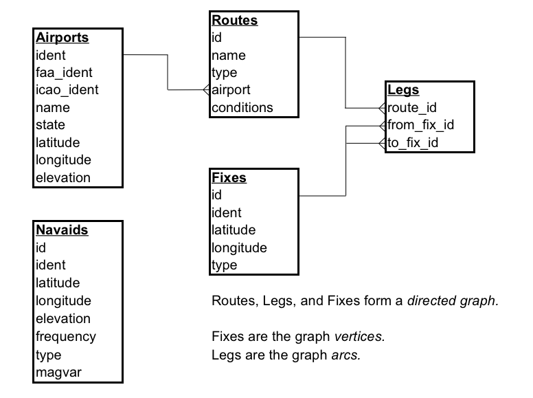
[ airports | runways | navaids | fixes | routes | legs || csv | sgb | sqlite ]
Airports
An example airport:
Airport:
  faa_ident: ITO
  icao_ident: PHTO
  name: "HILO INTL"
  state: HAWAII
  latitude: 19.7203333333
  longitude: -155.0485
  elevation: 38
Try not to make assumptions about FAA and ICAO identifiers. Not all airports have 4 letter ICAO identifers:
Airport:
  faa_ident: Y91
  name: "HOME ACRES SKY RANCH"
  ...
And not all FAA identifiers have three letters:
Airport:
  faa_ident: 05AK
  name: "WASILLA CREEK AIRPORT"
  ...
The last assumption I've seen is that the ICAO identifier is simply 'K' in front of the FAA identifier. This doesn't work for Alaska and Hawai'i.
[ airports | runways | navaids | fixes | routes | legs || csv | sgb | sqlite ]
Runways
Runway information for a subset of airports, pulled from NGS data.
Example runway:
Runway:
  airport: PHTO
  ident: 3
  latitude: 19.7124899722
  longitude: -155.062438972
  elevation: 33.7
  length: 5600
  width: 150
[ airports | runways | navaids | fixes | routes | legs || csv | sgb | sqlite ]
Navaids
An example Navaid:
Navaid:
  ident: ITO
  latitude: 19.7213611111
  longitude: -155.0109444444
  elevation: 23
  frequency: 116.9
  type: VORTAC
  magvar: -11
Example types include: VOR, VORTAC, VOR/DME, LOM, NDB, LOC, LOC/DME, LOC|SDF, LDA, LDA/DME.
[ airports | runways | navaids | fixes | routes | legs || csv | sgb | sqlite ]
Fixes
A fix is any aviation waypoint, including intersections, all airports, and all navaids.
A couple of example fixes:
Fix:
  ident: PHTO
  latitude: 19.72033333
  longitude: -155.0485
  type: AIRPORT

Fix:
  ident: ITO
  latitude: 19.7213611111
  longitude: -155.010944444
  type: VORTAC

Fix:
  ident: OKALA
  latitude: 20.0218888889
  longitude: -155.264638889
  type: FIX
The ident is not unique: there are several identically named NDBs, for example.
[ airports | runways | navaids | fixes | routes | legs || csv | sgb | sqlite ]
Routes
Routes can be Victor routes, high altitude JET routes, departure procedures (DPs), Standard Terminal Arrival Routes (STARs), or placeholders for instrument approaches.
A couple of example routes:
Route:
  name: BETTE3.BETTE
  type: DEP
  airport: KJFK

Route:
  name: BETTE3.ACK
  type: DEP
  airport: KJFK

Route:
  name: PARCH.PARCH1
  type: ARR
  airport: KJFK
  conditions: "LDG RWYS 4 L/R, 13 L/R, 31 L/R"

Route:
  name: PARCH.PARCH1
  type: ARR
  airport: KJFK
  conditions: "LDK RWYS 22 L/R"

Route:
  name: V22
  type: VIC
[ airports | runways | navaids | fixes | routes | legs || csv | sgb | sqlite ]
Legs
Consider routes as a directed graph. Fixes are the graph vertices. Legs are the graph arcs.
Most routes are undirected: there are two leg records for each actual leg:
Leg:
  route: V16
  from_fix_id: OKALA
  to_fix_id: TIGAH

Leg:
  route: V16
  from_fix_id: TIGAH
  to_fix_id: OKALA
But some routes are directed: Departure procedures and STARs, for two examples.
There are also leg records for every instrument procedure. There is one leg record for every IAF or IF to the destination airport.
[ airports | runways | navaids | fixes | routes | legs || csv | sgb | sqlite ]
CSV - Comma Separated Values
Each table of aviation data is available as a separate file in CSV format, suitable for importing into spreadsheets.
The first row of each file is meta-data, name=value pairs that describe the file. Example:
start=2010-11-18T09:01:00,end=2011-01-13T09:01:00,version=1.0,note=NOT FOR NAVIGATION
| Name | Description | Format | Example |
|---|---|---|---|
| start | Effective start date of the data | ISO 8601 date/time format | 2010-11-18T09:01:00 |
| end | Effective end date of the data, 56 days past the start date | ISO 8601 date/time format | 2011-01-13T09:01:00 |
| version | Version of the software that created the CSV | major.minor[.release] | 0.1 |
| note | Do not use this data for navigation |
The second row is the normal CSV header, upper-case column names.
latitude is a floating point, positive (0..90.0) for North, negative (0..-90.0) for South.
longitude is a floating point, positive (0..180.0) for East, negative (0..-180.0) for West. elevation is in feet MSL.[ airports | runways | navaids | fixes | routes | legs || csv | sgb | sqlite ]
SGB - Stanford Graphbase
Donald Knuth's classic book The Stanford Graphbase has a lot of clever routines for dealing with graphs.
The entire FAA route structure is stored as a single .gb graph, suitable for use with restore_graph.
Look at the example program shortest_path.c for an example on how to use Dijkstra's shortest path algorithm to find a route between any two airports.
Data types:
| Graph | uu.S | effective start date, in ISO 8601 format |
|---|---|---|
| vv.S | effective end date, in ISO 8601 format | |
| ww.S | version of software creating the data | |
| xx.S | NOT FOR NAVIGATION | |
| Vertex | name | FAA fix identifier |
| u | internal SGB hashing | |
| v | internal SGB hashing | |
| w.I | latitude of fix in integer arcseconds (divide by 3600.0 to get degrees) | |
| x.I | longitude of fix in integer arcseconds (divide by 3600.0 to get degrees) | |
| y | internal SGB Dijskstra algorithm | |
| z | internal SGB Dijsktra algorithm | |
| Arc | len | length of route leg, in arcseconds (1/60 of a nautical mile) |
| a.S | name of route |
[ airports | runways | navaids | fixes | routes | legs || csv | sgb | sqlite ]
SQLite
Look at routes.sql for the schema.
A sample command line session with SQLite data:
$ sqlite3 routes_24MAY2018.db
sqlite> select * from airports where icao_ident='PHTO';
PHTO|ITO|PHTO|HILO INTL|HAWAII|19.720333333|-155.0485|38
The database has an extra table, properties, consisting of key/value pairs.
| Property | Type | Description |
|---|---|---|
| start | ISO 8601 date/time | Effective date |
| end | ISO 8601 date/time | Effective end date |
| version | String major.minor[.release] | Version of software creating the database |
| note | String | Not for navigation |